Published at March, 12 2018
Updated on February, 06 2026
Performance-based navigation
Share the page
The implementation of performance-based navigation (PBN), in accordance with the provisions of Commission Implementing Regulation (EU) 2018/1048 of 18 July 2018 laying down airspace usage requirements and operating procedures concerning performance-based navigation (PBN Regulation), has multiple objectives: greater respect for the environment through optimized flight paths and lower costs associated with the radio navigation aids network to be maintained.
The French Air Navigation Service Provider (DSNA) is responsible for implementing the PBN Regulation for metropolitan and overseas aerodromes where it provides air traffic services, including those where an aerodrome flight information and alerting service (AFIS) is available at certain times. It is also responsible for implementing these regulations for routes and most departures and arrivals (SID or STAR routes).
PBN glossary
PBN stands for performance based navigation.
Depending on the flight phase, PBN requirements can be met by:
- Basic GNSS (Global Navigation Satellite Systems) constellations, such as GPS, in combination with augmentation systems (such as ABAS or SBAS);
- Radio navigation aids (VOR/DME or DME/DME navigation).
Performance specifications to be met are established for each phase of flight.
ATS routes for en route operations: RNAV 5 navigation specification
The RNAV 5 navigation specification requires that on-board equipment maintains lateral and longitudinal navigation accuracy along the route of 5 NM or better for at least 95% of the total flight time. This specification does not require any on-board navigation performance monitoring and alerting.
SID or STAR routes: RNAV 1 navigation specification
The RNAV 1 navigation specification requires that on-board maintains lateral and longitudinal navigation accuracy along the route of 1 NM or better for at least 95% of the total flight time. This specification does not require any on-board navigation performance monitoring and alerting.
Approach procedures: RNP APCH navigation specification
RNP (Required Navigation Performance) final approach procedures require on-board navigation performance monitoring and alerting for the trajectory followed.
To this end, the on-board equipment uses either an ABAS (Airborne Based Augmentation System) or SBAS (Satellite Based Augmentation System) such as EGNOS (European Geostationary Navigation Overlay Service) for Europe.
The ABAS system enhances the basic GNSS constellations for a given aircraft by providing integrity information.
The SBAS system enhances the basic GNSS constellations in a given region by broadcasting integrity and correction information via geostationary satellites. Such systems require ground receiving stations located at key points.
RNP approach procedures are published on a chart named RNP RWY xx, which offers three types of operational minima.
| Operational Minima | Sensor and augmentation required (a minima) | Guidance provided |
| LNAV (Lateral NAVigation) | GPS + ABAS | Lateral only |
| LNAV/VNAV (Lateral NAVigation/Vertical NAVigation) | GPS + ABAS Barometric system | Lateral and vertical Vertical guidance is based on altitude data provided by a barometric sensor, which depends on the QNH data entered by the pilot on board. |
| LPV (Localiser Performance with Vertical guidance), | GPS + SBAS | Lateral and vertical Vertical guidance is based on a WGS 84 altitude established from SBAS signals. |
No specific operational authorisation is required to conduct RNP APCH approach procedures.
During PBN approaches with vertical guidance, improved crew situational awareness and stabilised approaches are possible through the provision of vertical guidance. This enables pilots to perform standardised procedures, particularly at secondary IFR aerodromes.
In addition to RNP approach procedures, there are two other types of PBN approach procedures:
- RNP AR approach procedures: RNP AR APCH navigation specification
RNP AR (Authorisation Required) final approach procedures require a higher level of navigation performance that is better suited to overcoming the problem of access to airports located in obstacle-rich environments, for example, and facilitate the evolution of air traffic management (ATM). These procedures require operators to meet additional aircraft and crew requirements and to obtain operational authorisation from the State supervisory authority.
- RNP (VPT) approach procedures: visual manoeuvring procedures on a prescribed trajectory with PBN guidance support
The navigational accuracy of current avionics and the flexibility of PBN route design, combined with the principle of visual manoeuvring, make it possible to propose routes that meet environmental challenges by taking urban areas into account as much as possible while optimising the distance flown and the descent profile (CDO). These procedures do not require the operator to meet RNP AR requirements for aircraft and crews but do require operational authorisation from the State supervisory authority.
Finally, the benefits of PBN operations can also be exploited in ‘PBN to ILS’ procedures, which combine the flexibility of constructing an initial PBN approach trajectory with the performance of an ILS precision approach. These procedures are particularly beneficial for continuous descent operations.
PBN implementation in DSNA area of responsibility
Regarding approach procedures, the DSNA's compliance rate with PBN regulations, which stood at 98% in July 2025, will reach 100% by the end of 2025.
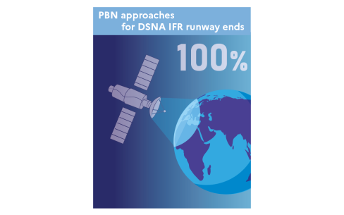
PBN approaches for DSNA IFR runway ends
PBN approaches for DSNA IFR runway ends : 100%
The numerous publications of PBN approach procedures with vertical guidance, either with LPV (Localizer Performance with Vertical Guidance) minima or with LNAV/ VNAV (Lateral NAVigation & Vertical NAVigation) minima on almost all runway ends, provide aircraft operators with additional access, particularly on a number of runways where precision approaches could not be implemented, with access being subject only to the operational minima of visual approach procedures.
The level of aircraft equipment is essential to enable the deployment of PBN approaches and maximise their benefits for users.
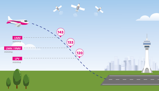
Trajectoire RNP
Illustration montrant un avion en approche de piste guidé par des signaux satellites. Trois niveaux de minima d’approche sont indiqués : LNAV, LNAV/VNAV et LPV. La trajectoire descendante de l’avion est marquée par trois points portant les valeurs 143, 133 et 120. En bas de l’image, on voit la piste d’atterrissage, quelques arbres, une tour de contrôle et une ville en arrière‑plan.
About SID and STAR routes, 143 runways are equipped with RNAV 1 SIDs and 138 runways are equipped with RNAV 1 STARs, representing deployment rates of over 90%.
Finally, all ATS routes are now RNAV 5: AIP publications have been updated in accordance with the RNAV 5 provisions of the PBN regulation.
What do you want to know about DSNA PBN strategy ?
Why promote RNP approaches with LPV minima?
LPV procedures offer the same minima as ILS CAT I procedures.
SBAS technology is as reliable and effective as ILS CAT I operations and can therefore complement ILS services by providing identical operational minima and maintaining safe and optimal accessibility. The lateral and vertical guidance provided by an SBAS such as EGNOS is free of charge and does not involve airport infrastructure costs.
SBAS therefore fully meets the performance requirements for navigation and trajectory monitoring: safety, accessibility, accuracy and integrity.
Furthermore, these operations do not require any specific training for crews.
The first SBAS CAT I approach in Europe was implemented at Paris CDG on 28 April 2016.
For almost 10 years, airlines and aircraft manufacturers have been able to clearly see that SBAS technology guarantees much greater airport accessibility than other types of RNP approaches. The operational benefits, in addition to the very high safety standards provided by EGNOS, reinforce DSNA conviction that SBAS (System Based Augmentation System) is a key technology in the modernisation of its navigation aid infrastructure.
DSNA has been a pioneer in rolling out these procedures to make the benefits of EGNOS available to all air users and thus encourage retrofitting.
What is DSNA position on RNP approaches with LNAV/VNAV minima?
Today, LNAV-VNAV minima approach procedures based on barometric information are the most commonly used satellite navigation approaches by airlines, but these operations are vulnerable in that vertical plan management depends on the QNH value entered by the crew into the on-board systems.
The consequences of this vulnerability have been highlighted in recent years by several serious incidents, the most recent of which occurred on 23 May 2022 involving the A320 aircraft registered 9H-EMU at Paris CDG. The study conducted by DSNA determined that the rate of inconsistency between the QNH displayed on-board and the QNH recorded by air traffic control systems is particularly high (around 1 in 1,000 for errors greater than or equal to 2 hPa and around 1 in 10,000 for errors greater than or equal to 10 hPa), leading to a significant gap between the expected level of safety and the level of safety actually provided. This situation has led the State supervisory authority, which is responsible for approving aerodrome operating minima, to plan to raise the minima for RNP approach procedures with LNAV/VNAV minima and RNP AR approach procedures.
This feedback confirms DSNA position in favour of LPV procedures, which offer numerous benefits in terms of availability (no RAIM), accessibility (LPV minima) and safety (independent of QNH).
What is DSNA position on RNP 1 and RADIUS TO FIX?
Except for specific purposes, the RNAV 1 navigation specification is used for SIDs and STARs routes. DSNA reserves the publication of PBN trajectories compliant with the RNP 1 specification for cases where the use of a ‘Radius to Fix ‘(RF) guided turn is necessary, or when the confinement of trajectories around the prescribed trajectory - which is an RNP 1 requirement - is an important asset. In other cases, the RNAV 1 specification is more effective: it is accessible to more aircraft and can be used directly in surface navigation mode using DME as a positioning source (for equipped aircraft) in the event of loss or degradation of the GNSS signal, whereas this mode is not certified, with very few exceptions, for RNP 1 avionics.
Does DSNA plan to implement RNP AR and RNP (VPT) procedures?
DSNA has been involved in ambitious and varied PBN deployments for many years. DSNA is therefore the European air navigation service provider that has deployed the largest number of PBN flight trajectories to date, but also the one with the greatest diversity.
In addition to the RNP approach procedures required by the PBN regulation, DSNA is working to find solutions that will enable procedures to be published for runway ends where this is not currently possible. DSNA is therefore working on the implementation of RNP AR APCH procedures, advanced procedures that require specific equipment from air operators to improve the accessibility of certain runway ends. These procedures are being developed in close collaboration with the companies that have expressed a need for them.
For more than 10 years, the DSNA has been working closely with Air France on the implementation of visual manoeuvring procedures on prescribed trajectories with PBN guidance support. Since 2015, several assessments have been carried out by DSNA with Air France in Bordeaux and Nice, and the positive feedback has now prompted DSNA to embark on the operational implementation of these procedures, known as RNP (VPT). These procedures have one thing in common: the use of a curved segment to reach the runway centreline and a CDFA-type descent in visual conditions. DSNA strategy is therefore to implement the concept set out in Part 1 of ICAO Circular No. 359, namely RNP (VPT) procedures based on an RNP AR trajectory. The first RNP (VPT) procedure was implemented in Bordeaux in January 2024, and others are currently being studied, such as in Marseille, where an obstacle-rich environment is also a problem and requires crews to follow a steep slope. These procedures are being developed in close collaboration with the airlines that have expressed a need for them.
Looking into the future with GBAS CAT II/III ?
A Ground-Based Augmentation System (GBAS) is a system that supports the augmentation of the basic GNSS constellation at the airport level for all phases of approach: landing, departure, and surface operations. While the main objective of GBAS is to provide integrity assurance, it also increases signal accuracy.
The DSNA supports R&D for CAT II/III GBAS and signed a memorandum of understanding in July 2021 to participate in the European GBAS Growth (EGG) consortium, with the aim of eventually deploying GBAS for CAT III operations at Paris CDG. Studies are continuing, considering various scenarios. The objective is to substantially improve the airport's performance in low visibility conditions.
Vidéo - GBAS CAT II III concept

What is DSNA position towards GBAS CAT I ?
For CAT I operations, the DSNA does not plan to deploy a GBAS system, given the relatively high costs involved and the availability of CAT I ILS or CAT I PBN SBAS approaches, which should be available before 2030 at all instrument runway ends, with LPV minima (either SBAS CAT I or APV 1 SBAS) available since January 2024 in accordance with the PBN regulation.
From ILS to PBN
ILS rationalisation’s objectives
In 2016, the DSNA finalised its plan to rationalise ILS (Instrument Landing System) equipment.
The ILS is an expensive landing aid system because it requires the installation of Localiser and Glide transmitters and antennas at each end of the equipped runway. DSNA bears all of these costs, in addition to the operational maintenance costs at all equipped aerodromes for which it is responsible.
The rationalisation of DSNA ILS network, carried out in parallel with the plan to implement PBN procedures, has reduced its internal costs. This ‘navigation aid’ strategy is a comprehensive strategy that contributes to the reduction of the terminal air traffic services charge (RSTCA).
A consistent and collaborative process
DSNA has defined a list of consistent criteria for identifying aerodromes for which it will no longer maintain ILS systems in operational condition. Airlines, airport operators and representative associations have been regularly consulted to reach a balanced agreement. The following factors were considered:
- the maximum distance between two aerodromes equipped with an ILS,
- the publication and systematic implementation of PBN approach procedures prior to any withdrawal,
- an in-depth meteorological study of each of the aerodromes under consideration.
2015 ILS NETWORK

MINIMUM ILS NETWORK SINCE 2016
In green, ILS taken over by airport operators
